Study Guide
Field 008: Geography
Sample Multiple-Choice Questions
Expand All Answers | Collapse All Answers
Subarea 1—GEOGRAPHIC CONCEPTS AND SKILLS
Objective 001
Understand geographic terms, concepts, and resources.
1. The concept of demographic transition provides a model for:
- analyzing government responses to changing patterns of total population growth.
- examining the relationship between economic development and natural population change.
- explaining major patterns of global population movement throughout history.
- analyzing spatial variations in the distribution, growth, and movement of population over time.
- Enter to expand or collapse answer.Answer expanded
- Correct Response: B.
Objective 002
Apply methods for conducting geographic investigations and analyzing and interpreting geographic information.
2. Use the passage below to answer the question that follows.
Synthetic pesticides and herbicides are not the only products used in modern industrial agriculture that can damage the environment. Significant amounts of fertilizers also enter rivers and lakes. When this occurs, fertilizers increase nutrient levels in the water, which can trigger rapid growth of aquatic plants that use up oxygen supplies, causing significant reductions in fish populations.
Which of the following responses best describes the writer's main purpose in the passage?
- to raise questions about products used in modern industrial agriculture
- to compare the effects of different types of toxins on aquatic environments
- to analyze the relationship between agriculture and fish mortality
- to describe the potential environmental impact of inorganic chemical fertilizers
- Enter to expand or collapse answer.Answer expanded
- Correct Response: D.
3. Use the graph below to answer the question that follows.
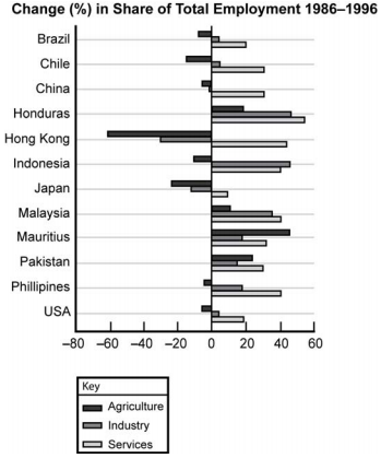
The graph is labeled "Change (%) in Share of Total Employment 1986 to 1996." The horizontal axis has values labeled from negative 80 to 60 in increments of 20. The vertical axis is labeled with the names of 12 countries. Data bars extend to the right and left from a vertical line at value 0. The key indicates that the various bars represent Agriculture, Industry, and Services. The values for each country are as follows. Values are approximate.
Brazil. Agriculture, negative 8. Industry, 5. Services, 21.
Chile. Agriculture, negative 15. Industry, 5. Services, 32.
China. Agriculture, negative 5. Industry, negative 1. Services, 32.
Honduras. Agriculture, 20. Industry, 48. Services, 50.
Hong Kong. Agriculture, negative 61. Industry, negative 30. Services, 46.
Indonesia. Agriculture, negative 10. Industry, 46. Services, 40.
Japan. Agriculture, negative 24. Industry, negative 12. Services, 10.
Malaysia. Agriculture, 12. Industry, 35. Services, 40.
Mauritius. Agriculture, 45. Industry, 18. Services, 32.
Pakistan. Agriculture, 24. Industry, 18. Services, 32.
Philippines. Agriculture, negative 5. Industry, 19. Services, 40.
U S A. Agriculture, negative 6. Industry, 4. Services, 19.
According to the graph, in which country between 1986 and 1996 did agriculture, industry, and services contribute most equally to economic development?
- Pakistan
- Honduras
- Hong Kong
- Malaysia
- Enter to expand or collapse answer.Answer expanded
- Correct Response: A.
Subarea 2—PHYSICAL SYSTEMS, NATURAL RESOURCES, AND LAND USE
Objective 003
Understand physical features of the earth and the natural processes that shape the earth's surface.
4. Use the diagram below to answer the question that follows.
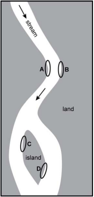
The diagram shows an overhead view of a stream. The direction of flow is indicated by an arrow. The stream flows from the upper left, down toward the right, then curves to flow down toward the left, where it splits to flow around an oblong island. At the first bend, the bank on the inside of the curve is labeled A, and the bank on the outside of the curve is labeled B. At the island, the upper left bank of the island is labeled C, and the lower right bank of the island is labeled D.
In which of the lettered areas of the diagram would erosion most likely change the shape of the streambed?
- letter A
- letter B
- letter C
- letter D
- Enter to expand or collapse answer.Answer expanded
- Correct Response: B.
5. Which of the following forces play the most significant role in producing climate variations in different parts of the world?
- air movement and the evaporation of moisture
- global ice pack density and oceanic circulation patterns
- wind speeds and locational elevations
- levels of incoming solar radiation and atmospheric circulation patterns
- Enter to expand or collapse answer.Answer expanded
- Correct Response: D.
Objective 004
Understand global ecosystems, natural resources, and patterns of land use.
6. Use the map below to answer the question that follows.
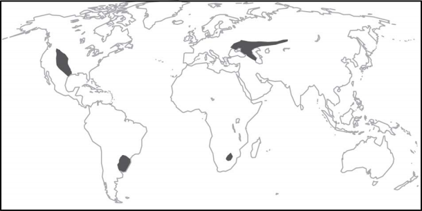
The map is of the world. There are four shaded areas. One is in the central region of North America, stretching from the Gulf of Mexico into western Montana. One is on the coast of South America, centered between the easternmost and southernmost points of the continent. One is in Asia, stretching from the region between the Black Sea and the Caspian Sea eastward into central Asia. One is in southern Africa, somewhat northeast of the southernmost tip of the continent.
The shaded areas on the map indicate the location of which of the following types of biomes?
- grassland
- desert
- taiga
- savanna
- Enter to expand or collapse answer.Answer expanded
- Correct Response: A.
Subarea 3—HUMAN SYSTEMS AND HUMAN–ENVIRONMENT INTERACTION
Objective 005
Understand human culture, human settlement, and global and regional patterns of population growth, distribution, and migration.
Use the population pyramids below to answer the two questions that follow.
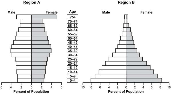
There are 2 population pyramids, one for Region A and one for Region B. The horizontal axis for each is labeled "Percent of Population." The vertical axis for both is labeled "Age." The horizontal axis for Region A has values marked from 0 to 6 in increments of 2, extending to the left for male and to the right for female. The horizontal axis for Region B has values marked from 0 to 10 in increments of 2, extending to the left for male and to the right for female. The vertical axis has values marked from 0 to 75+ in increments of 5, beginning with 0 to 4, 5 to 9, 10 to 14, through 70 to 74 and ending at 75+. The pyramid of Region A is narrow at the base, with values of approximately 2.7 for both male and female of age 0 to 4, widens to values of approximately 4 for both male and female of age 35 to 39, decreases gradually through the age of 70 to 74, then widens abruptly to a value of approximately 3 for males and 6 for females of age 75+. The pyramid for Region B is widest at the base, with values of approximately 8.1 for male and 8.2 for female of age 0 to 4, and tapers to a point, with values of approximately .5 for both male and female of age 75+.
7. Which of the following is the most likely explanation for the differences in the population pyramids?
- Region A has a higher dependency ratio than Region B.
- Region B has a higher population density than Region A.
- Region A has a higher childhood mortality rate than Region B.
- Region B has a higher total fertility rate than Region A.
- Enter to expand or collapse answer.Answer expanded
- Correct Response: D.
8. Based on information presented in the population pyramids, it is reasonable to infer that, compared with governments in Region A, governments in Region B will be devoting a greater proportion of state spending over the next decade to which of the following needs?
- school construction
- communication infrastructure
- health care
- highway development
- Enter to expand or collapse answer.Answer expanded
- Correct Response: A.
Objective 006
Understand the nature and effects of human interactions with the environment.
9. Extensive deforestation of tropical rain forests affects geosystems by:
- altering wind patterns in the atmosphere.
- increasing rates of atmospheric moisture accumulation.
- reducing water retention in the lithosphere.
- modifying the absorptive properties of the earth's surface.
- Enter to expand or collapse answer.Answer expanded
- Correct Response: D.
Subarea 4—WORLD REGIONS AND GLOBAL ISSUES
Objective 007
Understand characteristics, processes, and issues of major regions of the Eastern Hemisphere.
10. Which of the following Eastern Hemispheric areas have a similar climate?
- eastern Europe and Manchuria
- Scandinavia and Japan
- northern India and central Australia
- North Africa and Indonesia
- Enter to expand or collapse answer.Answer expanded
- Correct Response: A.
11. Which of the following is a major goal of political leaders responsible for administering the European Union?
- establishing the political and economic foundations for a gradual evolution from individual sovereign nations to a single unified state
- resolving territorial conflicts and economic disputes between member nations
- creating a common geographical space in which goods, people, and information can move freely between member nations
- developing a mutual defense alliance to protect the national sovereignty of member nations
- Enter to expand or collapse answer.Answer expanded
- Correct Response: C.
Objective 008
Understand characteristics, processes, and issues of major regions of the Western Hemisphere.
12. Which of the following cultural characteristics most distinguishes societies in the Caribbean islands from the rest of Latin America?
- the influence of Catholicism on cultural development
- the persistence of significant communities of indigenous peoples
- the African ancestry of the majority of the population
- the blend of European and indigenous social structures
- Enter to expand or collapse answer.Answer expanded
- Correct Response: C.
Subarea 5—HISTORY AND GEOGRAPHY
Objective 009
Understand basic historical concepts.
13. A historian would most likely employ the concept of feudalism when examining the relationship between:
- kinship networks and the distribution of wealth in a tribal society.
- political authority and land distribution in a preindustrial society.
- farmers and merchants in an agricultural society.
- family organization and the division of labor in a pastoral society.
- Enter to expand or collapse answer.Answer expanded
- Correct Response: B.
Objective 010
Understand history and the relationship with geography within major eras of U.S. history.
14. A knowledge of which of the following geographic factors would likely prove most useful to a researcher seeking to explain the emergence of the U.S. "manufacturing belt" during the late nineteenth century?
- the rate of national population growth and major patterns of national population movement
- the drainage pattern of the Mississippi River and the topography of the region
- the power-generating capacity of regional rivers and the rise of a national transportation network
- the location of mineral resources and the proximity of places to navigable waterways
- Enter to expand or collapse answer.Answer expanded
- Correct Response: D.
Objective 011
Understand history and the relationship with geography within major eras of world history.
15. Which of the following historical developments caused the greatest degree of interaction between European, Muslim, and Asian societies during the period from 600 CE to 1200 CE?
- the conquests of major European states
- the proselytizing activities of Christian missionaries
- the expansion of Islam
- the commercial activities of Chinese merchants
- Enter to expand or collapse answer.Answer expanded
- Correct Response: C.
16. Which of the following elements of culture have been most resistant to the forces of cultural globalization in the modern world?
- religious beliefs and practices
- literature and the arts
- patterns of work and leisure
- culinary traditions
- Enter to expand or collapse answer.Answer expanded
- Correct Response: C.
Subarea 6—OTHER INTERDISCIPLINARY PERSPECTIVES
Objective 012
Understand basic economic concepts and the relationship between economics and geography.
17. Use the passage below to answer the question that follows.
Advocates of protectionism fail to recognize that trade is the result of national differences. Because these differences are unlikely to disappear, efforts to limit global commerce are futile. This is certainly a good thing for countries able to expand their production possibilities by specializing in what they do best.
The writer's argument in the passage is based primarily on which of the following economic concepts?
- economic efficiency
- marginal utility
- comparative advantage
- economies of scale
- Enter to expand or collapse answer.Answer expanded
- Correct Response: C.
18. Which of the following statements best describes a major international economic trend of the late twentieth and early twenty-first centuries?
- North-South trade exceeded East-West commercial exchanges.
- Former command economies reduced their level of involvement in the global marketplace.
- Levels of international investment increased markedly.
- Eastern Hemisphere producers lost global market share in a broad range of industries.
- Enter to expand or collapse answer.Answer expanded
- Correct Response: C.
Objective 013
Understand basic political science concepts and the relationship between political science and geography.
19. The main purpose of the ten constitutional amendments contained in the Bill of Rights is to:
- prevent political corruption.
- limit the powers of government.
- maintain social order.
- ensure equality of opportunity.
- Enter to expand or collapse answer.Answer expanded
- Correct Response: B.
20. The causes of the various ethnic conflicts that occurred in Sub-Saharan Africa during the mid- to late-twentieth century can best be understood by examining:
- population movement within the region.
- the political boundaries established by European imperialists in the region.
- resource scarcity within the region.
- the divergent political and economic systems in the region.
- Enter to expand or collapse answer.Answer expanded
- Correct Response: B.